| Location | Kleinfeltersville | Trail Type | Loop |
| Distance | 4 miles (can vary) | Foot Traffic | Light |
| Difficulty | Easy | Elevation Gain | 512 feet |
| Recommended For: | Beginner, Family Fun |
The Middle Creek Wildlife Management Area is a bird watcher’s paradise. The more than 80 acres of land were initially established as a sanctuary of sorts for waterfowl such as Canadian Geese, when their numbers reached critical lows. Now it’s a safe haven and key migration spot for snow geese and tundra swans as well as home to short-eared owls, ospreys, red-tail hawks, American black ducks, and even bald eagles.
Best time to visit, if you’re hoping to see the thousands of birds that flock to the area, is the first week of March and late fall, when the birds are migrating. They cover the fields and reservoir in numbers that you just have to see to believe. The Middle Creek Wildlife Management Area is technically part of State Game Lands #46 and is a popular place for hunters, so be sure to wear blaze orange if visiting during hunting season.

There are 12 designated trails in Middle Creek, so there’s really something for everyone — hikers, bikers, bird watchers, boaters and anglers, kids, and hunters. There’s a fantastic map available on the PGC’s website that shows them all as well as parking locations. I’ve included a brief description and distance of some of my family’s favorite trails at the end of this post. Many of these trails intersect, and they’re all pretty well marked, so you can easily create your own hike and go explore whatever interests you most!
The Trail: Easy Version
This hike is an easy loop, great for beginners or families who are exploring with children. It uses just three of the area’s trails, but there are several ways you can make it a more difficult hike by including other, steeper trails, and extending the length. (If that interests you, skip to the next section for just a few options on making this a more difficult hike.)
We parked on a small pull-off just south of the Middle Creek Reservoir on Mountain Spring Road (coordinates in the Directions & Parking section) and began our counter-clockwise hike on the Horse-shoe Trail. The only real elevation gain — approximately 400 feet over a half-mile stretch — but it’s a light grade, without any tricky spots to navigate, but it is a horse trail, so don’t be surprised if your boots get a little muddier than usual.
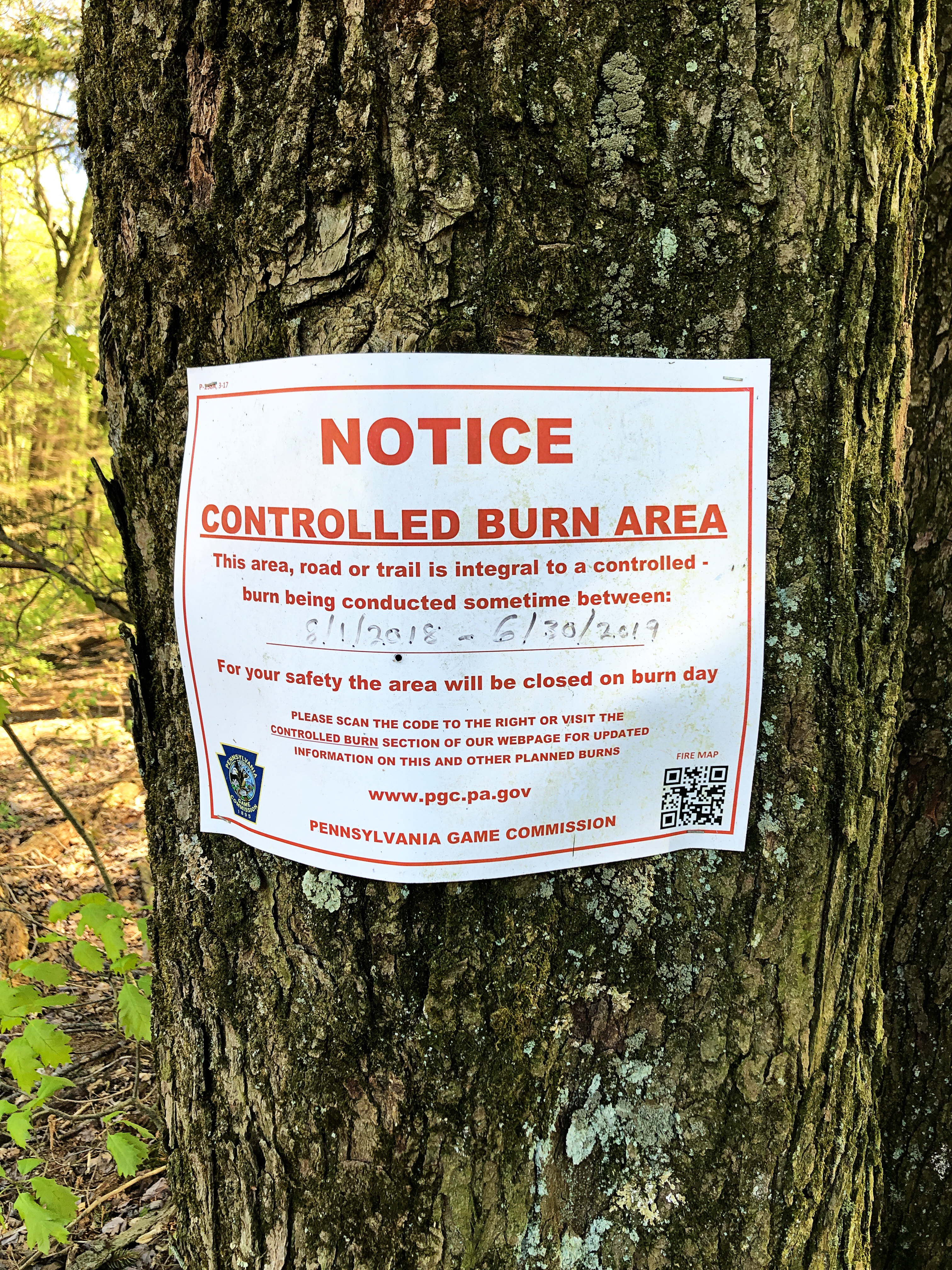
At the top, we kept left to continue on the Horse-shoe trail, passing power lines and intersections for the Spur to Valley View trail. The next half mile or so was an easy downhill on a well-rutted mud road. There was a park-style bench under a tree where we stopped for a quick snack and to determine which way to go next. The Horse-shoe Trail (yellow blazes) continued West, but there were notices about it being a “Controlled Burn Area” (invasive plants are making headway here), so we opted to head South on the Elder Run Trail.
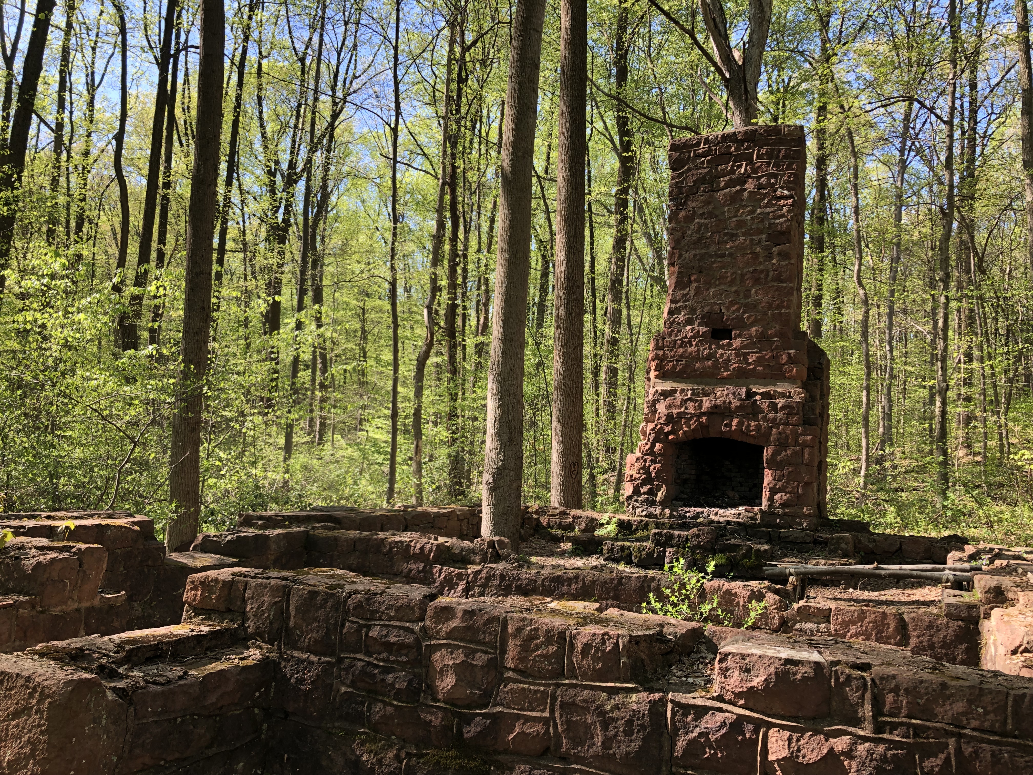
The Elder’s Run Trail is a wide and easy going old dirt road with orange blazes. From the trail you can see the remains of a small house. Most of the foundation is still in tact, and there’s even a small cellar entrance around the side, where I imagine root vegetables were once kept. It sparked a very lively conversation and interesting questions from my young daughter. We wondered what the house looked like when it had walls and who lived here. Was it someone’s home? A hunting cabin? A weekend retreat in the woods? How old is it? This line of conversation kept going for about a mile, when we hit our next trail switch.
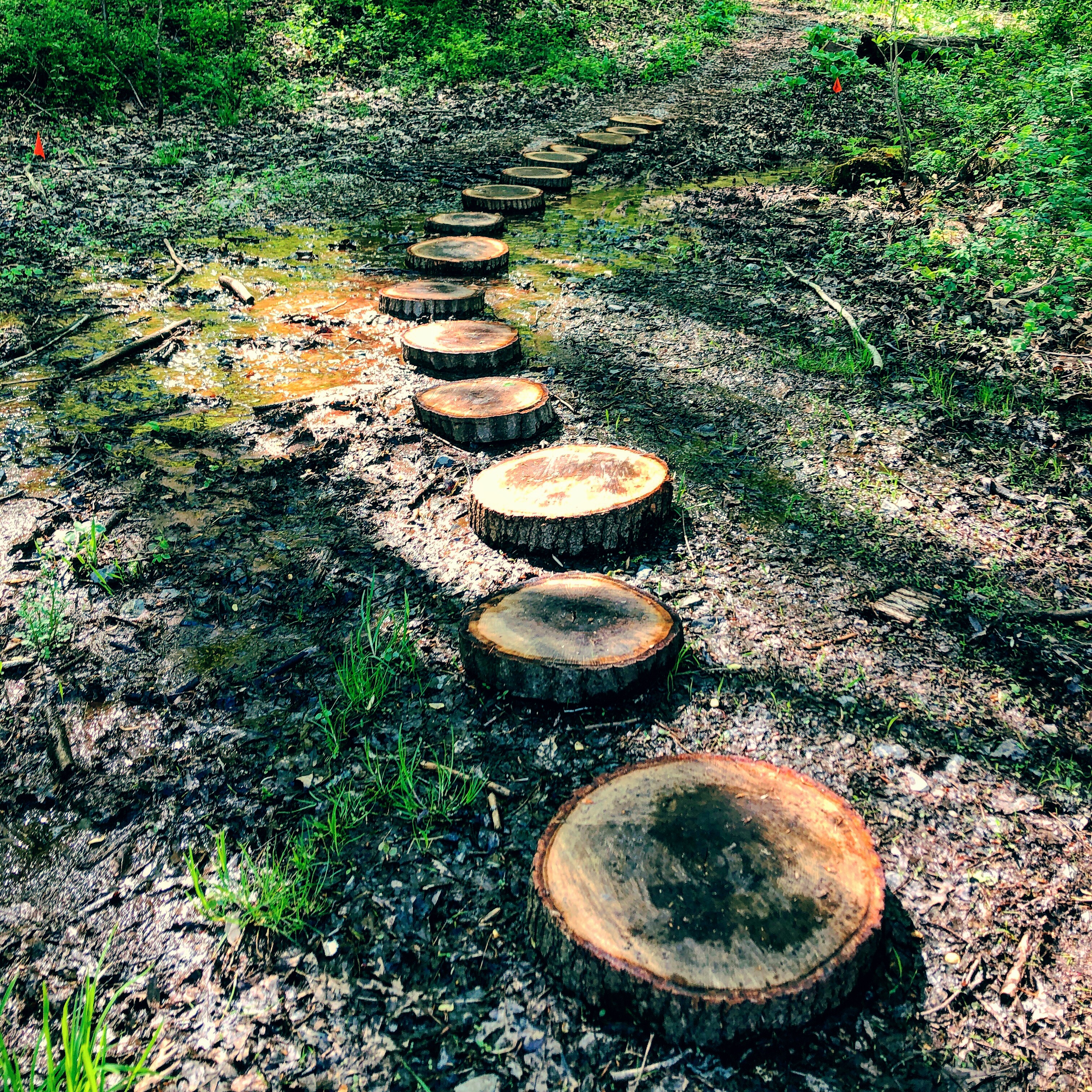
After a large wooden bridge crossing, we came to the intersection of Elder’s Run and Middle Creek Trails. Continuing South on Elder’s Run from here leads to a parking lot on Mountain Spring Road. We took the left-hand turn to head back North on the purple-blazed Middle Creek Trail to get back to where we had parked.

Middle Creek Trail is much more narrow than the Elder Trail and offers quite a couple small wooden bridges and walkways. It runs parallel to Middle Creek (of course). Private homes are visible from across the creek, and you’re likely to hear the sounds of civilization.

We followed Middle Creek for a flat, easy and mile and a half, completing the loop where we had started.
Easy Alternate Hike
Another easy, though slightly longer version of this hike would be to take the Horse-shoe Trail to the Volunteer Trail (first intersecting trail on the right, 0.3 miles long). Continuing straight from there, you’ll pick up the Fire Line Trail (0.3 miles), which turns into the Demonstration Plots Trail (0.3 miles) and connects with the Elder’s Run Trail. This version clocks in at about 5.5 miles instead of 4 miles.
The Trail: Moderate Options
You could easily make this hike more difficult by traveling clockwise instead of counter-clockwise, for more of a progressive ascent. Elder’s Run Trail is a pretty steady upward climb.
Another option is to use the Alternative Easy Hike and add the Valley View Trail (left-hand turn, green blazes). Valley View is a steep loop up the ridge, through a series of switchbacks to the top, delivering a nice view of the reservoir below. From there, you can take either the aqua-blazed Spur to Valley View Trail, which leads to the Horse-shoe Trail, or you can return down the other section of Valley View Trail to rejoin the Fire Line Trail and continue from there.

Directions & Parking
Address (Visitor’s Center) — 100 Museum Road, Stevens PA 17578
Pull-off Parking (limited room) — 40.26507, -76.23869
Reservoir Parking — 40.268306, -76.238972
From Pennsylvania Turnpike Exit 286: Take Route 272 North for three miles, and at the traffic light, turn left on Route 897. Follow Route 897 North for about 14 miles into the village of Kleinfeltersville. In Kleinfeltersville make the first left after the stop sign (Hopeland Road). The Visitors Center will be on the right about 2 miles down Hopeland Road.
From Pennsylvania Turnpike Exit 266: Take Route 72 North (about 4-5 Miles to Route 419 North. Follow Route 419 North for approximately 7 miles to Route 897 in Shaefferstown. follow Route 897 South for about 2 miles to Kleinfeltersville. Turn right a Hopeland Road in Kleinfeltersville. The Visitors Center will be on the right about 2 miles down Hopeland Road.
Nearby Trails
- Willow Point Trail (0.4 miles) – paved path to a lakeside vista for observing waterfowl.
- Conservation Trail (1.4 miles,) – loop from the Visitor’s Center, up to a ridge, through forest, field, and wetlands. Great for kids.
- Valley View Trail (1.0 miles, green blazes) – Steep loop starting at Laurel Drive parking area. Climb the ridge through a series of switchbacks to a vista. Connects to Horse-Shoe Trail at the top and with Spicebush Trail at the bottom.
- Spur to Valley View (0.2 miles, aqua blazes) – connects the Horse-shoe Trail to Valley View Trail.
- Spicebush Trail (0.8 miles) – Starts across old Sunfish Pond Dam, follows a small stream through wetlands and forest. Connects with Valley View Trail. Great for kids.
- Horse-shoe Trail (8.1 miles, yellow blazes) – approximately 8 miles in Middle Creek. Begins at Valley Forge National Historic Park and ends at the Appalachian Trail north of Hershey.

One thought